Tourist Attractions

TOWER

Torre is the highest point of Serra da Estrela. It is accessible by a paved road and belongs to three municipalities: Manteigas, Seia, and Covilhã. With breathtaking scenery year-round, it is especially known for the snow that, during winter months, attracts thousands of tourists.

Photo: Luis Agostinho

PENHAS DA SAÚDE

Located in the heart of Serra da Estrela, Penhas da Saúde sits at 1,500 meters above sea level. With a wide range of accommodation and dining options, it is one of the most sought-after spots by tourists on snowy days.

Lady of the Good Star

Carved into the rock along the road leading up to Torre, the statue of the saint who protects shepherds is one of the most impressive monuments in Serra da Estrela. Frequently visited by the curious, this sanctuary is well worth a stop.

Bear’s Rock

Located on the way from Covilhã to Penhas da Saúde, this giant bear-shaped rock catches the eye of many visitors and locals alike.

COVÃO DO BOI

Situated above 1,850 meters of altitude, Covão do Boi is where the statue of Nossa Senhora da Boa Estrela is carved into the rock. This area is well-known for having the largest cluster of granite blocks.

Padre Alfredo Dam

Also known as Covão de Ferro Lagoon, this dam marks the beginning of the Alforfa glacial valley that extends to Unhais da Serra. Surrounded by a unique natural landscape, it’s a must-see location.

Viriato Lake Dam

With an approximate height of 28 meters from the base, the main function of this concrete dam is water supply. It is also a popular spot for nature lovers.

ALFORFA GLACIAL VALLEY

Located on the opposite side of the Zêzere Glacial Valley and composed of massive rock blocks, this valley impresses with its landscape. It is a key stop along many hiking trails.

TRAILS

The Gateway to Estrela Mountain

The PR11 CVL – The Gateway to Estrela Mountain is a linear route that entirely follows the T14 Crossing of the Serra da Estrela Natural Park (PNSE) and the Grand Route of the Estrela Geopark.

This route connects the city of Covilhã, considered the main gateway to Serra da Estrela, to the central massif of the park, ending at the Snow Clearing Centre in Piornos.

Characterised by a steep gradient, this route is of high difficulty, functioning as a connection between the main tourist services in the region and the various existing pedestrian route networks. It plays a key role in the structuring of walking opportunities in Covilhã and Serra da Estrela.

Along the route, it is possible to appreciate various geological formations and landscapes of great natural value, such as Pedra do Urso, Alto das Piçarrinhas, the National Forest, and the recently renovated Carqueijais Viewpoint, offering privileged panoramic views of the valley.

Forest route

The PR12 CVL – Forest Route is a circular route that follows easy paths, aiming to explore the natural heritage on-site, highlighting the historical connection between the city of Covilhã and Serra da Estrela.

Starting from the Alexandre Aibéu Park, you will explore the valleys of the Carpinteira and Goldra rivers (also known as the Pisões river), discovering the area of the city’s National Forest.

Along the way, the connection between the water running here and the wool industry is clear, allowing you to discover old factories, renovated buildings, chimneys, and place names related to this activity.

Granite Route

PR13 CVL – Granite Trail is a moderately difficult trail that guides you through landscapes and unique rock formations that have accompanied shepherds since time immemorial. Located in the heart of Serra da Estrela at about 1,500 meters altitude, Penhas da Saúde is surrounded by breathtaking flora and fauna. Its charm goes beyond the white winter mantle — with the spring thaw, new colors emerge and create a vibrant natural palette.

From the tourist village of Penhas da Saúde, this medium-difficulty circular trail makes the most of the area’s geological richness. It reveals impressive granite formations along old shepherds’ paths, with highlights including Covão do Teixo (Curral do Vento area) and panoramic views over Cova da Beira from Alto das Capinhas.

Other key landmarks include Bear Rock (Pedra do Urso) and Lapa do Esgalhado.

Shepard's Balcony Route

PR14 CVL – Shepard’s Balcony Route runs across the plateau near Penhas da Saúde and offers a great introduction to the Serra da Estrela.

This moderately difficult circular trail explores the natural and human dynamics of high-altitude pastures. It highlights two key forces shaping the contemporary mountain landscape: natural phenomena (glaciation, periglacial features, fauna, and flora) and human activity (shepherding, rural and industrial life, and modern tourism).

As it crosses the Alto da Pedrice plateau, it reveals traditional shepherd shelters and impressive geomorphological features of Covilhã.

Main highlights: Viriato Dam, Água Fria Stream, and Malhada do Prior.

Rota das Canadas de Unhais

The PR16 CVL – Rota das Canadas de Unhais is a challenging route linking the village of Unhais da Serra to the highest point in mainland Portugal, traversing paths and canadas used by shepherds.

The Unhais da Serra Canadas are an ancient heritage strongly associated with transhumance, connecting the village to mountain pastures. This route challenges you to travel along canadas and paths through the Alforfa river valley, one of the first to harness its waters for electricity production, before ascending to the glacial cirque and reaching the Torre plateau.

Wild Beijames Paths

This network of paths explores the upper section of the Beijames Valley and forms a circular route leading to Aguilhão, the dramatic edge of this pristine valley.

NOTE: Not fully marked and high difficulty.

Eco Trail

PR22 CVL – Eco Trail is a linear trail of about 16 km running along the southwestern slopes of Serra da Estrela, between Sarzedo and Teixoso. Hikers can observe the interaction between human settlement and natural values.

Passing by agricultural terraces and forests, it features interesting sites like the ruins of an old mill and the Fonte dos Amieiros, an ideal resting spot.

Photo: Leonardo Rosa

Wool Route North

PR23 CVL – Wool Route North stretches nearly 18 km and connects Verdelhos to Covilhã. The trail follows historic paths used by rural workers commuting to textile factories in Covilhã, as well as shepherds traveling to pastures along the Beijames River.

Milkmaids’ Route

PR24 CVL – Milkmaids’ Route runs from Bouça to Covilhã and tells the story of villagers who commuted to work in textile industries and brought milk to market in Covilhã. The trail contrasts the hardship of rural life with the stunning granite-dominated landscapes.

Photo: Gonçalo Poço

Charcoal Makers’ Route

PR25 CVL – Charcoal Makers’ Route retraces the journeys of locals who transported and sold charcoal in Covilhã. It was also used by shepherds during transhumance to higher altitudes.

Charcoal Makers’ Route

PR26 CVL – Ribeira da Lapa Trail is a short circular route following the Lapa stream as it flows toward Vila do Carvalho. Along the way, geological pools carved by the river over time can be observed, including Poço das Cambalhotas, Poço da Água Quente, Poço do Manuel Ganhão, and Poço da Argola.

Photo: Leonardo Rosa

Viewpoints

Varanda dos Carqueijais Viewpoint

Varanda dos Carqueijais is a viewpoint located halfway between the city of Covilhã and Penhas da Saúde in Serra da Estrela, near the Carqueijais Hotel.

From this viewpoint, visitors can see the flat surface of the Cova da Beira. At the base of the slope lies the city of Covilhã, which stretches to the foot of the mountain where the ascent of Serra da Estrela begins.

It is a must-stop location.

Piornos Viewpoint

After Varanda dos Carqueijais, another viewpoint is found in the Piornos area of Serra da Estrela. At an altitude of approximately 1,630 meters, this new addition to the Serra da Estrela Viewpoint Network was built on the slope of a granite tor to offer a unique and inspiring landscape shaped by ancient glaciers.

The metal structure was adapted to the terrain’s features and blends harmoniously with the landscape, minimizing its visual impact. It now stands as a new, safe, and comfortable balcony for visitors to observe the Nave de Santo António and the western plateau.

Covão Viewpoint

Located in the heart of Serra da Estrela, along the descending direction of the EN 339 road, this viewpoint is part of the Covilhã Viewpoint Network. It features a suspended platform offering views of the Zêzere Glacial Valley. In addition to the landscape, this new structure provides visitors with unique experiences.

Alto dos Livros Viewpoint

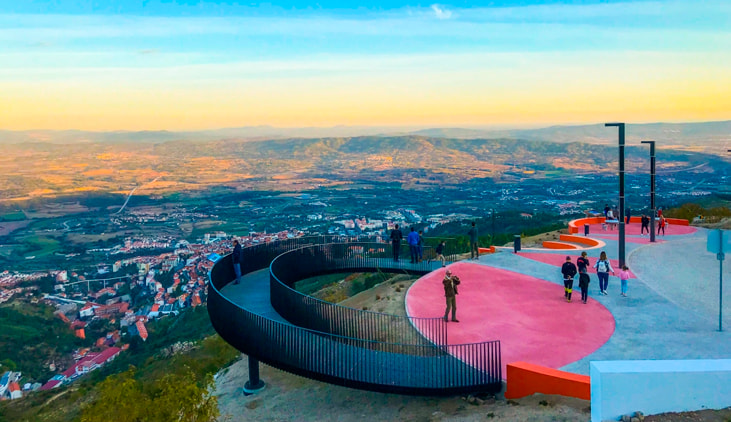
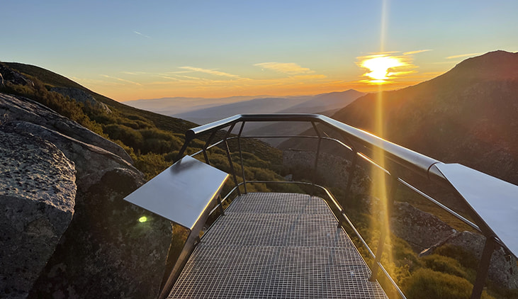
Developed from a geological formation reminiscent of stacked books — hence its name — this impressive viewpoint is yet another spot for visitors to enjoy and contemplate, offering breathtaking landscapes. It forms part of Covilhã’s Network of Viewpoints and stands as a place of memories from times past.